
Matt and I had reserved 3 days of travel time to make it to Allentown, PA for MTB Nationals , so the grand plan was to stop along the way and find places to bike that were close to I-80. Simple enough, I did some research, got some opinions of locals, and put a plan into place. We said our goodbyes to Cheyenne at 10pm on July 13th, and headed Mr. Fozzy east into the great abyss that is Nebraska.
Driving all day Sunday was done for one goal – getting to our first destination in Iowa!
Trail #1 – Sugar Bottom Trail System – North Liberty, IA

Iowa, I must apologize. I cracked so many jokes about “I can’t wait to see a hill in Iowa” and had just general doubt about how the trails would be. Sugar Bottom changed all of that for me! This system was started in 1990, and consists of singletrack that winds through dense forests and pine groves along a reservoir. All the trails (aside from the central fire road) are directional, which is definitely helpful considering all the blind corners and lack of visibility you’ll have while riding them. There are north and south trail systems, all connected to the central fire road. Each trail intersection is marked, and in fact I really don’t think a person needs a map! Matt and I started at one end, and just kept going and going until we worked our way completely around. I love systems that are so well marked maps are not needed!
Link to trail system map: http://www.icorrmtb.org/wp-content/uploads/2010/03/SugarBottom_r6_Basic.pdf
Both the north and south systems have a main “beginner” loop, and off of these spur harder intermediate/expert loops that loop back close to where they started on the main loop. This makes it very easy to pick and choose trails and the length you desire to ride! Matt and I tried to jump off on all the spurs we could find. This is where we did enjoy a chuckle, as an “expert” marked trail in Iowa doesn’t really equate to what we would call an expert trail here in southeastern Wyoming. The expert trails maybe would have a bit of roots or tricky switchbacks, or perhaps a foot drop, but nothing too extreme that someone with some time on their MTB couldn’t ride. The funnest expert trail we found was “Cyclocross Hill,” which is a bit swoopy downhill over a bridge and then straight up this insanely steep hill. I attempted it but chickened out at the bottom of the hill when I saw how really steep it was. Matt made it to the top like the rockstar he is. Next time, Iowa, next time!

This was just the trail system to begin my acclimation to horrible humidity, rooty terrain, and lack of elevation. The humid weather left me drenched not too soon from jumping on the bike, but I noticed how happy my lungs felt. And due to the relatively low elevation (I consider anything lower than 3000 feet “sea level” so take my elevation comments how you please), I felt like I could just go for days and days. The tight switchbacks, especially on climbs, helped me develop some of those skills.
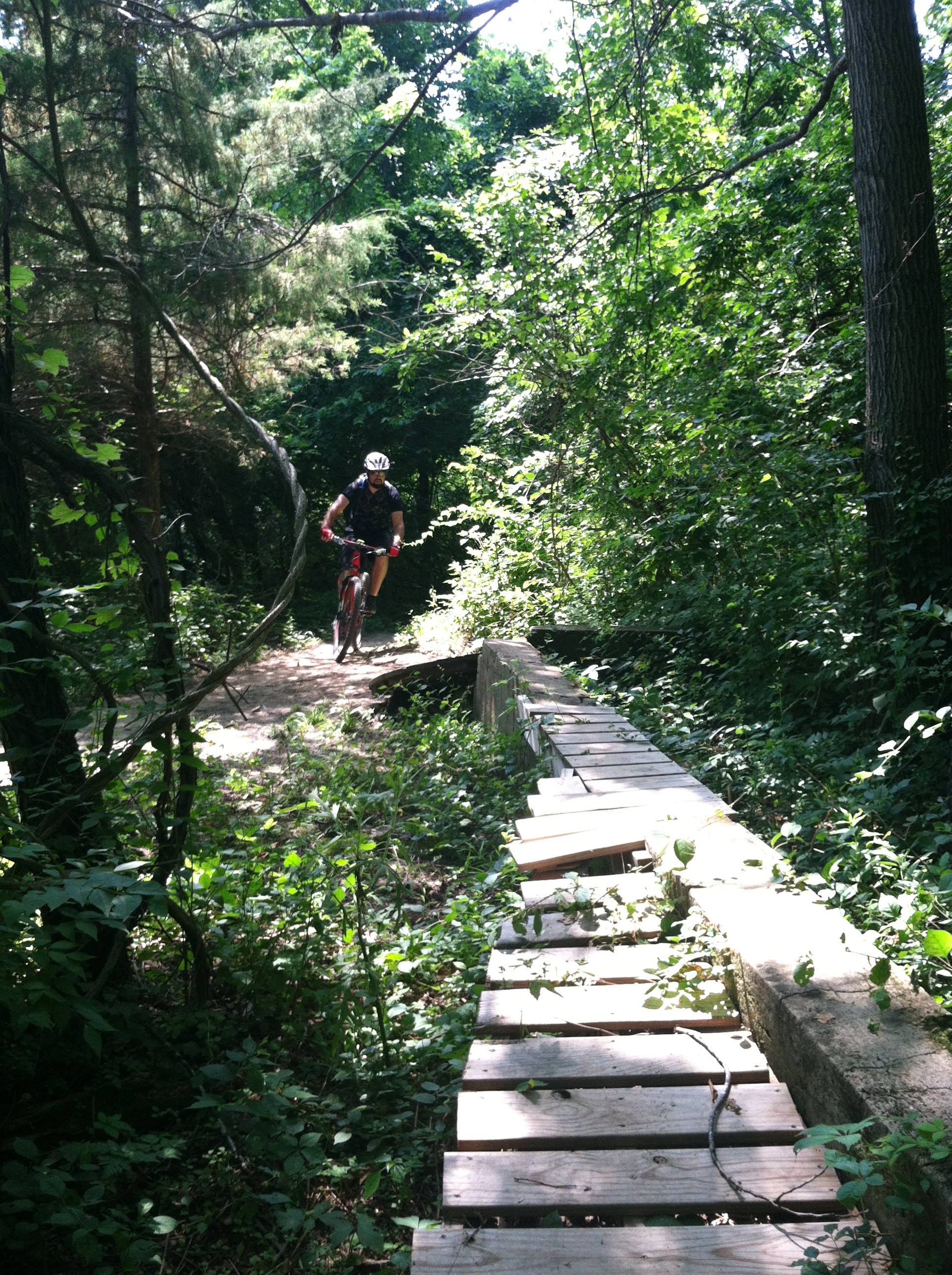

Overall we did 10.5 miles, which included over 1,100 feet of climbing. Iowa, you did well in the elevation gain department! Another perk to the trail system is that we only ran into 3 other people the whole time (and 3 people hiking the wrong way on the trail…), so you can get nice and spread out from other people!
We called it a day in the Davenport area, got a hotel, enjoyed a nice shower to wash the sweat and dirt off, and had a burger at Steak n Shake.
Trail #2 – Illiniwek Forest Preserve – Hampton, IL
Next up on the list was Illiniwek Forest Preserve, which is along the bluffs over the Mississippi River on the Illinois side. This was actually the first trail system that I had decided on when planning the trip. It is maybe only an hour or so from Sugar Bottom, but since we stayed overnight we decided this would start our morning off before hitting the road again.

Once again, these were singletrack-ish (might be a little wider than typical singletrack) trails through dense woods that climb and descend a bluff. Some roots, but otherwise smooth sailing. Heck, we saw a 5 year old tearing up these trails. Kid friendly! Not a lot of miles unless you do multiple laps, but enough for a quick and very satisfying ride!
Once again, this trail system is split into north and south loops. The north loop as an overlook you can go to for the Mississippi River. “They” say that the north loop has more climbing, but both loops seemed comparable to me. It was definitely fun coming down with banked corners! These trails are not directional, however, so don’t ride like too much of an asshat.

Link to trail map: http://www.qcforc.org/trails/ifp/IFPTrailMap.pdf
We did encounter a freshly downed tree on the south loop system, so we had to take a little re-route. No biggie, and I guess it was fresh since the day before according to someone I had run into who inquired why a Wyoming care was in the parking lot 😀 This guy comes out to Colorado and rides, so I recommended Curt Gowdy, and explained why we were where we were. Always nice to run into some fellow mountain bikers!
There is signage at some intersections, but there are not maps at every intersection. We didn’t get lost, and just took loops to see where we’d end back up. It was pretty easy to know how to find the car… go down!
All in all we did 5.7 miles for 344 feet of climbing. It is definitely easy on the climbs, nothing too insanely steep and all the switchbacks are more than doable.
Added bonus is that you’re on the Mississippi River, so we popped down to the riverbank with our bikes for an extra 2 miles to explore.


We cleaned up the best we could (thank goodness for baby wipes!) and jumped in the car for the journey across Illinois, Indiana, and half of Ohio. I initially was hoping we could make Royalview in Ohio for some riding, but I underestimated drive time so we settled into what is one of the nicest La Quinta Inns ever in Macedonia, OH and called it a night – only after a good meal at Bob Evans! We need those restaurants in Wyoming, I swear!
Trail #3 – West Branch State Park – Ravenna, OH
Another quick drive from the hotel for another morning of mountain biking, this time at West Branch State Park in Ohio. Oh man… I don’t even know where to begin. Let’s just say at least this trail made Bear Creek Resort in PA (the Nationals venue) look like a walk in the park. And it taught me all about nasty muddy wet trail systems with nasty wet roots and nasty mossy slick rocks. I’m pretty sure I shed tears riding these damn trails.
Trail map link: http://www.camba.us/pn/downloads/New%20West%20Branch%20Map.pdf
A common theme, once again there’s north and south trails all connected by a central road, Cable Line. We chose the southern trails along the reservoir first, as I heard they were milder. Immediately I took my glasses off because they kept fogging up due to the humidity. We slipped and slided along the trail, until we reached a flooded part. Uber flooded, like “no you won’t go pass Go” flooded. Matt happily tramped through the woods and found the road. Me on the other hand… I have a huge irrational fear of bugs, spiders, worms, nasty stuff. Humid east coast woods = nasty stuff. I swear it took him 5 minutes to convince me to walk through the woods. I dashed through, trying not to think of all the creepy crawly things that could get on me.
Then we jumped on the Gorge Trail on the north side. There is a slate bottom creek we had read about, and we wanted to find it. I think I for sure invented new curse words riding the rock gardens. Everything was just so wet and icky.

The slate bottom creek made the horrible trail worth it! Clear, cool flowing water, all over slate that you can easily ride a bike up and down (not very slippery at all!).


The bad about this trail system: lack of signage. Bring a trail map. And don’t listen to me when I say what direction the lake is in. Ugh. I suppose you could say we were lost. But we did make it back to the car. Not all was lost! We did 6.3 miles and 584 feet of climbing. Do I ever want to ride here again? No.
Got back to the car, discovered there’s no running water around the trailhead (a plus for Sugar Bottom), so I took SmartWater and used it to wash my body off. There’s only so much SmartWater and baby wipes can do, but I tried. We laughed at the fact our bike clothing and shoes were smelling something horrid after 3 days of use in humid/stinky climates. I get so spoiled by the ultra dryness of the West…
Eastward we turned for the final 5 hours of our trip. We passed the USA Cycling truck, which was nice surprise. Final stop before our glorious Red Roof Inn in Allentown would be the modern day ghost town of Centralia, PA. I’ll try to remind myself to make a whole post about our Centralia adventures!
We definitely enjoyed our little biking adventures on the trip out, and it was fun to see what different parts of the country have to offer for mountain biking! The trip home we did straight through, so we didn’t have the time to stop along I-70… another day!

